The farmer who knows the most knows best
Advanced satellite mapping and multispectral imaging for South African farms
Book a Farm AnalysisAbout KnowYourFarm
At KnowYourFarm.co.za, we deliver comprehensive multispectral land analysis using advanced satellite technology to provide South African farmers, game breeders, nature reserves, and livestock operations with precise, objective insights into their properties.
Our cutting-edge remote sensing capabilities analyze vegetation health, soil conditions, water retention, topography, and meteorological patterns to help land managers make informed, data-driven decisions that optimize productivity and sustainability.
Operating throughout South Africa with global coverage capability, we combine data science expertise with deep agricultural knowledge to translate complex satellite imagery into practical, actionable intelligence tailored to local farming and conservation challenges.
Founded by a data science specialist with lifelong experience in agriculture and nature conservation, we leverage artificial intelligence and advanced research methodologies to provide detailed analysis at competitive pricing points.
Our evidence-based approach eliminates guesswork from land management, delivering professional reports that reveal critical insights about soil health, vegetation patterns, erosion risks, and seasonal variations across your entire property.
We maintain open communication with our clients, encouraging questions about our analyses and providing ongoing support to help you implement our findings effectively for improved agricultural and conservation outcomes.
How It Works
Our comprehensive process for delivering actionable farm insights
1. Request Consultation
We begin with understanding your specific needs, challenges, and goals to tailor our analysis to your unique requirements.
2. Data Collection
We gather high-resolution satellite multispectral imagery (10m resolution) and combine it with precision weather data, in order to collect the most accurate data possible.
3. Multispectral Analysis
Our specialized algorithms process multispectral data to identify vegetation patterns, soil conditions, moisture levels, and topographical features specific to your property.
4. Expert Interpretation
Our specialists review the data analysis, applying their expertise in South African conditions to extract meaningful insights from the technical data.
5. Comprehensive Report
We compile our findings into detailed, easy-to-understand reports with custom maps, charts, and actionable recommendations specific to your properties unique characteristics.
6. Implementation Support
Our team provides ongoing support to help you understand our recommendations, answer questions, and maximize the value of your farm analysis investment.
Our Services
Comprehensive satellite mapping and analytics for your farm
Note: By investing in our analysis, you're not only receiving today's insights but also supporting our continuous development of new features and improvements, which you'll receive automatically at no additional cost.
Annual Farm Analysis
Complete analysis of your farm for a full calendar year, taking into account temperature, rainfall, bare soil conditions, plant health, topographical features, and plant moisture content.
Includes: Meteorological Analysis, Detailed Topographical Mapping, Soil Exposure Assessment, Plant Health and Density Monitoring using SAVI Index, and Plant Water Availability Analysis with Moisture Stress Mapping.
Farm Analysis for Prospective Buyers (In production)
A streamlined analysis package designed specifically for potential farm buyers. Helps assess comparative farm values with objective data rather than just visual impressions, enabling informed purchasing decisions.
Includes: Essential farm metrics, comparative analysis, potential assessment, and investment value indicators.
More Services Coming Soon
We're constantly developing new analytical tools and specialized services to help South African farmers make better decisions. Stay tuned for upcoming product announcements.
Future developments: Enhanced analysis methods, specialized crop monitoring, and more detailed farm management tools.
Investing in our growth: When you purchase any KnowYourFarm product, you're investing in our continuous improvement. As we enhance our methods, maps, or algorithms, you'll automatically receive updated analyses at no additional cost. You'll also gain access to new products as they're released, all included in your initial investment.
Our Technology
Advanced satellite imaging and analysis technologies for South African farms
Satellite Imaging
High-resolution (10m) multispectral satellite imagery acquisition and processing, providing detailed views of your farm across multiple light wavelengths to reveal information invisible to the human eye.
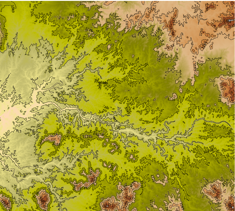
Topographical Mapping
High-precision elevation modeling with detailed gradient analysis, enabling you to identify optimal areas for there use cases, manage water flow, and implement erosion control measures with confidence.
Weather Data Analysis
Comprehensive meteorological graphing system that visualizes temperature ranges, averages, and rainfall patterns with daily precision, helping you understand climate trends and extremes specific to their property.
Custom Vegetation Mapping
Specialized vegetation indices calibrated specifically for South Africa's diverse ecosystems, providing accurate assessment of plant health and productivity across various biomes and land use zones.
Moisture Analysis
Advanced algorithms that detect plant moisture stress, enabling precise water management and identification of potential water-related issues before they impact crop yields or biodiversity.
Plant Photosynthesis Mapping
Cutting-edge spectral analysis that measures photosynthetic activity across your farm, identifying areas of optimal plant productivity and highlighting zones requiring intervention.
Barren Soil Analysis
Advanced algorithms that detect barren soil and plant density, allowing for precise locating of soil compaction and erosion risks.
Coming Soon
We are currently in the production of many more cutting edge technologies.
Book a Farm Analysis
See how KnowYourFarm can transform your agricultural operations
Use the ⭓ tool to outline your farm area, then click on all the corners of your farm
Your Data Privacy: The farm boundary you draw is used only for your demo request and analysis. We never share your farm data with third parties or use it for any purpose other than providing our services to you. All data is stored securely and confidentially.
What Our Clients Say
"Be the first one to tell us how KnowYourFarm.co.za helped you"
Your Farm Name Here
Farmer, Location
"Message +27 64 633 3562 to add your comment"
Your Farm Name Here
Farmer, Location